The Parishes of Charlotte County
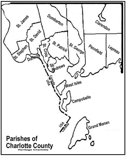
Parishes of Charlotte County - Map Copyright Heritage Charlotte
(Google Maps)
The county has fifteen parishes:
Parish of Campobello
Details - Formed in 1803, when it left the parish of West Isles. The island is located within the Fundy Islands. The island's northern coastline is on the Passamaquoddy Bay while its southern and western coastline is along the Bay of Fundy.. The only direct land transportation is via a bridge that connects the island to Lubec, Maine. There is a seasonal ferry service which operates between the island and Deer Island.
Boundaries - Being the island so named, and other islands to the south and east of Head Harbour Passage, but west of Grand Manan.
Parish of Clarendon
Details - Formed in 1869, from unassigned land in the parishes of Pennfield and Lepreau. This parish is located in the northeastern part of the county.
Boundaries - West by Saint George Parish; north and east by the County lines, and south by a line run true west from the most southern angle of Queens County to the eastern boundary of Saint George Parish.
Parish of Dufferin
Details - Formed in 1873, from a southeastern portion of the parish of St. Stephen.
Boundaries - Commencing in the centre of the channel of the St. Croix River opposite the mouth of Dennis Stream; thence following the centre of said channel down stream around Todds Point, so called, to Oak Bay, and up the centre of the channel of Oak Bay and of Pagans Cove, to where the northern line of lots fronting on northern side of St. Croix River intersects said cove; thence westerly and northwesterly along said line to the Bay Road, so called; thence westerly along said road to Dennis Stream, and thence down said stream to beginning.
Parish of Dumbarton
Details - Formed in 1856, from northern part of the parish of St. Patrick.
Boundaries - West by Saint David Parish and Saint James Parish; north by the County line; east by the northern prolongation of the eastern boundary of Saint Patrick Parish; and south by Saint Patrick Parish.
Parish of Grand Manan
Details - Formed in 1816, when it left the parish of West Isles. Grand Manan is the largest island in the county and second largest island in the province of New Brunswick. The island is service by year-round ferry operation which connects to the mainland at the village of Blacks Harbour.
Boundaries - Being the island so named and all the islands to the south and east thereof.
Parish of Lepreau
Details - Formed in 1857, from the eastern section of the parish of Pennfield. This parish borders along the eastern county line which borders with Saint John County and Kings County.
Boundaries - West by Pennfield Parish; north by Clarendon Parish; east by the County line; and south by the Bay of Fundy, including Pocologan, New River and Salkeld Islands, and all other islands in front within two miles of the shore.
Parish of Pennfield
Details - Formed in 1785. This parish is one of the original parishes of Charlotte County. This parish originally included the parish of Lepreau, however the parish of Lepreau was created in 1857. The parish's largest community is the village of Blacks Harbour.
Boundaries - Westerly by Saint George Parish and Letang River; north by Clarendon Parish; east by a line commencing at the western bank or shore of the Pocologan River, where it falls into the Bay of Fundy, and running true north to Clarendon Parish; and south by the Bay of Fundy, including The Wolves Islands, and all other islands within two miles of the shore and not included in Saint George Parish.
Parish of Saint Andrews
Details - Formed in 1785. This parish is one of the original parishes of Charlotte County. parish's largest community is the town of St. Andrews.
Boundaries - North by Saint Croix Parish and a direct line from the Southeast angle of Lot Number 11 granted to James Greenlaw to the most Western angle of Lot Number 20 granted to Francis Welsh; west by the St. Croix River south by Passamaquoddy Bay, and east by the west line of lot number twenty, granted to F. Welsh, including Ministers and Navy Islands.
Parish of Saint Croix
Details - Formed in 1874, from northern sections of the parish of St. Andrews. This parish received modifications in 1881 and 1896.
Boundaries - East and South by a line beginning at the most Northern angle of a four hundred and eighty-eight acre lot, granted to Daniel Hill, on Waweig River; thence Southeasterly, along the Northeastern limit of said lot, to the Western angle of Lot No. 3, granted to James McFarlane; thence Northeasterly, along the Northwestern limit of Lot No. 3, to the Northern angle of same; thence Southeasterly, along the Northeastern limit of Lots Numbered 3, 2, 1 and 12 and of Lot No. 13, granted to John H. Armstrong, to the Eastern angle of Lot No. 13; thence Southwesterly, along the Southeastern limit of Lot No. 13, to the Northeastern limit of the grant to William Reading; thence Southeasterly, along the Northeastern limit of the grant to William Reading to the Eastern angle of same; thence Southwesterly, along the Southeastern limit of the grant to William Reading, to the Northeastern limit of the grant to Rachael Mowat; thence Southeasterly, along said Northeastern limit to the Eastern angle of same; thence Southwesterly, along the Southeastern limit of lot granted to Rachael Mowat and of Lots Numbered 9, 8, 7, 6 and 5 to the Northeastern limit of Lot No. 4 granted to Maxwell Lawry; thence Southeasterly along said Northeastern limit of Lot No. 4, to the Eastern angle of same; thence Southwesterly along the Southeastern limit of Lots Numbered 4, 3 and 2 to the Southern angle of Lot 2, granted to Lauchlan Doon; thence Northwesterly along the Southwestern limit of Lot No. 2 to the Southeastern limit of Lot No. 28, granted to Moses J. Greenlaw; thence Southwesterly, along the Southeastern limit of Lot No. 28 to the Northeastern angle of Lot 29, granted to Jesse C. Bartlett; thence Southerly, along the Eastern limit of lot 29, to the Northwestern angle of Lot No. 45, granted to Jesse C. Bartlett; thence Easterly along the Northern limit of Lot 45 to the Northeastern angle of same; thence Southerly, along the Eastern limit of Lot 45, to the Northern limit of the hundred acre lot granted to Andrew Dougherty; thence Easterly, along the said Northern limit to the Western bank or shore of Bonaparte Lake; thence Southerly, along said bank or shore, to meet the Northerly prolongation of the Eastern limit of Lot No. 4 granted to Leonard Bartlett; thence Southerly along said prolongation and said limit to the Northern limit of Lot No. 3 granted to Thomas Sime; thence Westerly along said Northern limit to the Northwestern angle of Lot No. 3; thence Southerly, along the Western limit of Lots Numbered 3, 2 and 1 to the Southeastern angle of Lot No. 11 granted to James Greenlaw; thence Westerly, along the Southern limit of Lot No. 11, to the Eastern bank or shore of Little Chamcook Lake; thence Southerly along the Eastern bank or shore of Little Chamcook Lake and the Eastern bank or shore of Fry Mill Stream to the bank or shore of Chamcook Lake; thence Southerly, Westerly and Northerly along the Eastern, Southern and Western banks or shores of Chamcook Lake to the Northern limit of the five hundred acre lot granted to Colin Campbell, Thomas Wyer and William Gallop; thence Westerly, along said Northern limit, to the Eastern limit of lots fronting on the St. Croix River; thence Southerly along the Eastern limit of lots fronting on the St. Croix River to the Southeastern angle of Lot No. 38 granted to Daniel Grant; thence Westerly along the Southern limit of lot 38 to the St. Croix River; West by the St. Croix River and Saint David Parish, North by Saint David Parish including Rickets Island in Waweig River.
Parish of Saint David
Details - Formed in 1785. This parish is one of the original parishes of Charlotte County.
Boundaries - South by Dufferin Parish; west by the east line of lots on Dennis Stream prolonged southerly to Dufferin Parish and by the west lines of the grant to Henry Goldsmith and others; north by the north line of the said grant; east by the east line of the said last mentioned grant; southeast and southerly by a line commencing at the most northern angle of a four hundred and eighty-eight acre lot granted to Daniel Hill on Waweig River; thence southwesterly to the most western angle of the said lot; thence southeasterly to the northeast angle of lot number thirty, granted to W. Ross; thence westerly along the north line of the said last-mentioned grant and its western prolongation to the northeast angle of lot number eight, granted to James Garcelon; thence south to the southeast angle of lot number four, granted to James Christie; thence west to the southwest angle of the said last-mentioned lot; thence south along the eastern line of lots fronting on Oak Bay to Waweig River; thence down the channel of Waweig River and up the channel of Oak Bay to Pagans Cove, where the northern line of Dufferin Parish intersects it, excluding Rickets Island in Waweig River.
Parish of Saint George
Details - Formed in 1785. This parish is one of the original parishes of Charlotte County. The parish's largest community is the town of St. George. The Magaguadavic River passes through the town of St. George.
Boundaries - West by Saint Patrick Parish, Dumbarton Parish and Passamaquoddy Bay; north by the County line; east by the rear line of lot number three, granted to William Payne and its prolongation northerly to the County line, and southerly to Letang River; south by the Bay of Fundy, the channel to and through Letete Passage, and the channel to and through Letang Harbour and River, including Bliss Island.
Parish of St. James
Details - Formed in 1823, from north sections of the parish of St. Stephen and unassigned land. The western boundary of this parish border with the United States.
Boundaries - South by Saint Stephen Parish and Saint David Parish; east by the northerly prolongation of the east line of Saint David Parish; north by the County line; and west by the St. Croix River.
Parish of Saint Patrick
Details - Formed in 1785. This parish is one of the original parishes of Charlotte County. Previous to the establishment of the parish of Dumbarton, this parish stretched as far north as the county line.
Boundaries - West and northwest by Saint Andrews Parish and Saint Croix Parish; east by the west line of the grant to Philip Bailey and others, and its northerly prolongation; north by a line commencing at the most southern angle of lot number five, granted to John Gilman, on the southwestern side of Digdeguash River; thence northeasterly along the southeasterly line of said lot to the Digdeguash River; thence down stream along the same to the lower line of the lot granted to John Campbell; thence along the same easterly to the rear thereof; thence northerly along the rear of the said last mentioned lot to meet the westerly prolongation of the line dividing the lots ten and eleven in the Clarence Hill grant plan, and thence easterly along the said line dividing the lots number ten and number eleven to the eastern boundary of the parish; and south by Passamaquoddy bay, including all the islands west of the east line of the said parish within two miles of the shore.
Parish of Saint Stephen
Details - Formed in 1785. This parish is one of the original parishes of Charlotte County. parish's largest community is the town of St. Stephen, which is the largest municipality in the county. The St. Croix River passes along the town of St. Stephen.
Boundaries - South by Dufferin Parish and the St. Croix River; east by Saint David Parish, north and west by a line beginning in the intersection of the St. Croix River with the southwesterly prolongation of the northwestern limit of Lot No. 16, granted to Angus Rankin; thence northeasterly along said prolongation and said limit to the western limit of Lot No. 115, granted to Thomas Dodd; thence northerly along the western limits of Lots Numbered 115, 116, 117 and 99 to 114 inclusive to the southern limit of Lot No. 46 granted to Thomas Grimmer Junior; thence westerly along said limit and its prolongation to the eastern limit of Lot No. 60, granted to Robert M. Todd; thence northerly along the eastern limit of Lot No. 60 and its northerly prolongation, to meet the westerly prolongation of the northern limit of No. 53 granted to Peter Christie; thence easterly along said westerly prolongation, the northern limit of Lot No. 53 and the easterly prolongation of the northern limit of Lot No. 53, to the eastern bank or shore of Moore Lake.
Parish of West Isles
Details - Formed in 1785. This parish originally included all of the Fundy Island, however Campobello was assigned its own parish in 1803 and Grand Manan assigned its own parish 1816. The islands of Moose, Dudley and Frederick were transferred to the United States in 1817. Today, the parish includes Deer Island and any of the outlaying inhabited islands. Deer Island is serviced by a year-round ferry service to the mainland.
Boundaries - To consist of Deer Island and the lesser islands contiguous to it, not included in the parishes before-mentioned.
Community-Parish Reference
For quick searches, use "ctrl+F" and enter the name of the community that you wish to reference. Click Here to open the 'Parishes of Charlotte County' map in a new window.
|
PLACE NAME
|
PARISH
|
|
Abrahams Plain
|
Campobello
|
|
Adam Island
|
West Isle
|
|
Adelaide Lake
|
Pennfield
|
|
Anderson Settlement
|
St. James
|
|
Andersonville
|
St. James
|
|
Anthony Lake aka Antonio Lake
|
Pennfield
|
|
Back
Bay
|
St.
George
|
|
Back
Clarendon
|
Clarendon
|
|
Back Road
(see Bay Road)
|
St. David
|
|
Baileyville
aka Woodland
|
Maine
|
|
Baillie
Settlement
|
St. James
|
|
Bald
Head
|
West Isle
|
|
Bald
Head
|
Campobello
|
|
Bald Head Mountain
|
Clarendon
|
|
Bald
Hill
|
Clarendon
|
|
Bald
Hill
|
Dufferin
|
|
Bar Road
|
St.Andrews
|
|
Barber
Dam
|
St. James
|
|
Baring
|
Maine
|
|
Barnaby
Head
|
Lepreau
|
|
Barnes Island
|
West Isle
|
|
Barr Island
|
West Isle
|
|
Barter
Settlement
|
St.
Stephen
|
|
Bartlett
|
St.
Croix
|
|
Bartletts Mills
|
St.
Croix
|
|
Basswood
Ridge
|
St. James
|
|
Bay
Road
|
St. David
|
|
Bay
Shore
|
Pennfield
|
|
Bayside (aka Sandy Point)
|
St.
Croix
|
|
Beaconsfield
|
St. James
|
|
Bean's Island
|
West Isles
|
|
Bear Lake
|
Lepreau
|
|
Bear
Mountain
|
Clarendon
|
|
Beaver Harbour
|
Pennfield
|
|
Beaver
Pond, Deer Island
|
West Isles
|
|
Beech
Hill
|
Clarendon
|
|
Bell Tower Mountain
|
Clarendon
|
|
Belle View
(see Beaver Harbour)
|
Pennfield
|
|
Benson
Corner
|
St. David
|
|
Berry
Point
|
St.
Patrick
|
|
Bethel
|
St.
Patrick
|
|
Big
Bay (Bocabec Bay)
|
St.
Patrick
|
|
Big Meadow Lake, Deer Island
|
West Isles
|
|
Big Whale
Cove
|
Campobello
|
|
Birch
Cove
|
St.Andrews
|
|
Birch
Cove
|
St.
Patrick
|
|
Birch Hill
Settlement (see Back Clarendon)
|
Clarendon
|
|
Bird Island
|
St.
Patrick
|
|
Birneys Lake
|
Dumbarton
|
|
Black
Brook
|
St.
Patrick
|
|
Blackland
|
St.
Stephen
|
|
Blacks Harbour
|
Pennfield
|
|
Bliss Harbour
|
St.
George
|
|
Bliss Island
|
St.
George
|
|
Blueberry Mountain
|
|
|
Bocabec
|
St.
Patrick
|
|
Bocabec Bay (Cove) (see Big Bay)
|
St.
Patrick
|
|
Bocabec
Ridge (see Kerrs Ridge)
|
St.
Patrick
|
|
Bocabec River
|
St.
Patrick
|
|
Bog
Brook
|
|
|
Bonaparte Lake
|
St.
Patrick
|
|
Bonny
Brook
|
|
|
Bonny
River
|
St.
George
|
|
Bonny River Lake
|
St. Patrick
|
|
Bonny
River Settlement
|
St.
George
|
|
Boom Cove
|
St.
Patrick
|
|
Boreo Lake
|
Clarendon
|
|
Breadalbane
|
St.
George
|
|
Bridge
Brook
|
Clarendon
|
|
Brown
Head
|
Campobello
|
|
Bunker
Hill
|
Campobello
|
|
Burns
|
St.
Patrick
|
|
Burnt Hill
|
St.
Stephen
|
|
Butler
Point, Deer Island
|
West Isles
|
|
Caithness
|
St.
George
|
|
Calais
|
Maine
|
|
Calders
Head, Deer Island
|
West Isles
|
|
Campbell
Point
|
St. David
|
|
Campo Bello (see Welshpool)
|
Campobello
|
|
Campobello
Island
|
Campobello
|
|
Campobello
Parish
|
Campobello
|
|
Canal
|
St. George
Parish
|
|
Canoose
|
St. James
|
|
Canoose Lake
|
St. James
|
|
Canoose River
|
St. James
|
|
Cape
Ann (see St. David Ridge)
|
St. David
|
|
Caribou Lake
|
Clarendon
|
|
Carrs
Ridge (see Kerrs Ridge)
|
St.
Patrick
|
|
Casco Bay Island
|
West Isles
|
|
Castalia
|
Grand
Manan
|
|
Central
Tower Hill
|
St. David
|
|
Centreville
(see Castalia)
|
Grand
Manan
|
|
Chamcook
|
St.Andrews
|
|
Chamcook
Channel
|
St.Andrews
|
|
Chamcook
Corner (see Edwards Corner)
|
St.Andrews
|
|
Chamcook
Corner(see Edwards Corner)
|
St.
Croix
|
|
Chamcook Harbour
|
St.Andrews
|
|
Chamcook
Island (see Ministers Island)
|
St.Andrews
|
|
Chamcook Lake
|
St.Andrews
|
|
Chamcook Lake
|
St.
Croix
|
|
Chamcook Mountain
|
St.Andrews
|
|
Charlotteport (see Beaver Harbour)
|
Pennfield
|
|
Cherry Island
|
West Isles
|
|
Chocolate
Cove, Deer Island
|
West Isles
|
|
Christie
Landing
|
St. James
|
|
Christie
Town (see Milltown)
|
St.
Stephen
|
|
Clam Cove,
DI
|
West Isles
|
|
Clarence
Brook
|
St.
Patrick
|
|
Clarence
Hill (see Clarence Ridge)
|
St.
Patrick
|
|
Clarence Lake
|
Dumbarton
|
|
Clarence Ridge
|
St.
Patrick
|
|
Clarendon (see Back Clarendon)
|
Clarendon
|
|
Clarendon
Parish
|
Clarendon
|
|
Clark
Point
|
St.
George
|
|
Clarke's
Point
|
St.
George
|
|
Clear Lake
|
Pennfield
|
|
Clindenin
Ridge (see St. David Ridge)
|
St. David
|
|
Conan
Hill
|
Clarendon
|
|
Connosquamcook
(see St.Andrews)
|
St.Andrews
|
|
Coronary Lake
|
Lepreau
|
|
Covenhoven
(see Ministers Island)
|
St.Andrews
|
|
Cow Lake
|
St.
George
|
|
Cox
Brook
|
Dumbarton
|
|
Craftville
|
Clarendon
|
|
Cranberry Lake
|
Clarendon
|
|
Creasey Lake
|
St.
Patrick
|
|
Creighton
Point
|
St.
Patrick
|
|
Cripps
Stream
|
Pennfield
|
|
Crocker
Hill
|
Dufferin
|
|
Croftville
(see Craftville)
|
Clarendon
|
|
Crooked Lake
|
Pennfield
|
|
Crow Harbour
|
Pennfield
|
|
Crystal Lake
|
Clarendon
|
|
Cummings
Cove, Deer Island
|
West Isles
|
|
Curry
Cove
|
Campobello
|
|
Davidson
Head, Deer Island
|
West Isles
|
|
Deadman's Harbour
|
Pennfield
|
|
Deep
Cove
|
Grand
Manan
|
|
Deep Cove
Brook, Grand Manan
|
Grand
Manan
|
|
Deer
Cove
|
Campobello
|
|
Deer Island
|
West Isle
|
|
Deer
Island Point, Deer Island
|
West Isles
|
|
Deer Lake
|
Clarendon
|
|
Dennis Stream
|
St. David
|
|
Dennis Stream
|
St.
Stephen
|
|
DeWolfe
|
St. James
|
|
Dicks Island
|
St.
Patrick
|
|
Digdeguash
|
St.
Patrick
|
|
Digdeguash Harbour
|
St.
Patrick
|
|
Digdeguash Lake
|
St.
Patrick
|
|
Digdeguash River
|
Dumbarton
|
|
Digdeguash River
|
St. David
|
|
Digdeguash River
|
St.
Patrick
|
|
Dinner
Cove
|
Campobello
|
|
Dochet Island (aka St. Croix Island)
|
St.
Croix
|
|
Doctors
Cove, Deer Island
|
West Isles
|
|
Dog
Brook
|
St. James
|
|
Dougherty
|
St.Andrews
|
|
Dover
Hill
|
St.
Stephen
|
|
Dufferin
|
Dufferin
|
|
Dufferin Parish
|
Dufferin
|
|
Dumbarton
|
Dumbarton
|
|
Dumbarton
Parish
|
Dumbarton
|
|
Dumbarton
Station
|
Dumbarton
|
|
Dunn Island
|
St.
Croix
|
|
Dunn Island
|
St. David
|
|
Dyer
Brook/Stream
|
St.
Patrick
|
|
Dyer/Dyer
Settlement
|
St.
Patrick
|
|
Eagle Mountain
|
Lepreau
|
|
East
Brook, Grand Manan
|
Grand
Manan
|
|
East
Head
|
Pennfield
|
|
East Long Lake
|
Clarendon
|
|
East
Quoddy
Head Light
|
Campobello
|
|
Eastern
Head
|
Campobello
|
|
Eastern
Pond
|
Campobello
|
|
Eastern Wolf Island
|
Pennfield
|
|
Eastport
|
Maine
|
|
Edwards
Corner
|
St.
Croix
|
|
Edwards
Corner
|
St.Andrews
|
|
Elmcroft (aka Lee Seetlement)
|
St.
George
|
|
Elmsville
|
St.
Patrick
|
|
English Island
|
West Isles
|
|
E'tang Island
|
St.
George
|
|
Fairhaven, Deer Island
|
West Isles
|
|
Falls
Brook
|
St.
Patrick
|
|
Fiander Road
|
St.
Patrick
|
|
Fish Harbour, Deer Island
|
West Isles
|
|
Fish Island (aka
Le Treille)
|
West Isles
|
|
Five
Corners
|
St.
Stephen
|
|
Flat Wolf Island
|
Pennfield
|
|
Fletchers Island (aka Navy Island)
|
St.Andrews
|
|
Flume Falls
|
Dumbarton
|
|
Flume
Ridge
|
Dumbarton
|
|
Forked Lake
|
Pennfield
|
|
Foster Lake
|
St. David
|
|
Foster Road
|
St.
Patrick
|
|
Fountain
Cove (aka Cummings Cove)
|
West Isles
|
|
Four
Corners
|
St.
Stephen
|
|
French Village (see Blacks Harbour)
|
Pennfield
|
|
Friar's Bay
|
Campobello
|
|
Friar's
Head
|
Campobello
|
|
Fry's
Mill
|
Grand
Manan
|
|
Gallop
Stream
|
St. David
|
|
Getchell Settlement (see Mayfield)
|
St.
Stephen
|
|
Gibson Lake
|
St.
Croix
|
|
Gilman
Corner
|
St.
Croix
|
|
Glass
Point
|
St.
Patrick
|
|
Gleason
Point
|
St. James
|
|
Goat
Brook
|
St. James
|
|
Goldsmith Lake
|
St.
Croix
|
|
Gooseberry
Point
|
Campobello
|
|
Goss's
Corner
|
Dumbarton
|
|
Grand
Brook, Grand Manan
|
Grand
Manan
|
|
Grand
Falls
|
St. James
|
|
Grand Harbour
|
Grand
Manan
|
|
Grand
Manan Island
|
Grand
Manan
|
|
Grand
Manan Parish
|
Grand
Manan
|
|
Granite Town (see St. George)
|
St.
George
|
|
Great Duck Island
|
Grand
Manan
|
|
Green
Brown Brook
|
St. James
|
|
Green Island
|
West Isles
|
|
Green Island
|
Grand
Manan
|
|
Greencastle
|
Lepreau
|
|
Greenock
|
Dumbarton
|
|
Greens
Point
|
St.
George
|
|
Grimmers Mountain
|
St. James
|
|
Grimmock
|
St. Patrick/St. David Dumbarton
|
|
Grove
Settlement (see Bocabec)
|
St.
Patrick
|
|
Gundy Lake
|
Clarendon
|
|
Gunter's
Mill
|
Pennfield
|
|
Haggertys Cove
|
Lepreau
|
|
Half Moon Lake
|
Clarendon
|
|
Hannabury
|
Campobello
|
|
Hanson
Point
|
West Isles
|
|
Harbour De Loutre (Lute)
|
Campobello
|
|
Hardwood Island
|
St.
Patrick
|
|
Havelock
Hill (see Back Clarendon)
|
Clarendon
|
|
Hawkins Lake
|
Pennfield
|
|
Hayman
Hill
|
St.
Stephen
|
|
Head Harbour
|
Campobello
|
|
Head Harbour Island
|
Campobello
|
|
Head of
Letang
|
St.
George
|
|
Heart Lake
|
Clarendon
|
|
Heathland
|
St.
Stephen
|
|
Height of
Land
|
Clarendon
|
|
Helena Island
|
West Isles
|
|
Herring
Cove
|
Campobello
|
|
Herring
Cove Heath, Grand Manan
|
Grand
Manan
|
|
Hersonville,
Deer Island
|
West Isles
|
|
Hewitt
|
Dumbarton
|
|
Hibernia, Deer Island
|
West Isles
|
|
High Duck Island
|
Grand
Manan
|
|
Hills
Point
|
St. David
|
|
Hog Island
|
St.
Patrick
|
|
Holts Point/Holts Point Road
|
St.
Patrick
|
|
Honeydale
|
St. David
|
|
Hospital Island
|
St.
Patrick
|
|
Hospital Island
|
West Isles
|
|
Hoyt
Nub
|
St.
George
|
|
Hurd Lake
|
Lepreau
|
|
Indian Beach, Grand Manan
|
Grand
Manan
|
|
Indian
Cove
|
Lepreau
|
|
Indian Island (aka
La Treille's)
|
West Isles
|
|
Indian
Point
|
St.Andrews
|
|
Indian
Pond
|
St. James
|
|
Indian
Reserve (see Milltown)
|
St.
Stephen
|
|
Ingalls Head
|
Grand
Manan
|
|
Jake Lee
Brook
|
Pennfield
|
|
Jake Lee Mountain
|
Pennfield
|
|
Joe's
Point
|
St.Andrews
|
|
Johnson
Cove
|
St.
Croix
|
|
Johnson
Settlement
|
St.
Patrick
|
|
Jones
Brook
|
Dumbarton
|
|
Justasons
Corner
|
Pennfield
|
|
Katys Cove
|
St.Andrews
|
|
Kedron
Brook
|
Dumbarton
|
|
Kedron Lake
|
Dumbarton
|
|
Kellyland
|
Maine
|
|
Kendricks Lake
|
St. Stephen
|
|
Kent Island
|
Grand
Manan
|
|
Kerr Lake
|
St.
Patrick
|
|
Kerrs Ridge & Kerrs Ridge Road
|
St.
Patrick
|
|
Keyhole
Hills
|
Lepreau
|
|
Kilmarnock Head
|
St.Andrews
|
|
King
Brook
|
St. James
|
|
King Lake
|
St. James
|
|
Kitty's
Cove
|
St.Andrews
|
|
La Treille's Island (aka
Fish Island)
|
West Isles
|
|
Laborie
Hill, Grand Manan
|
Grand
Manan
|
|
Lake Glensevern
|
Campobello
|
|
Lake
Stream
|
St.
George
|
|
Lake Utopia
|
St.
George
|
|
Lambert's
Cove, Deer Island
|
West Isles
|
|
Lambertville,
Deer Island
|
West Isles
|
|
Lawrence Station
|
St. James
|
|
Ledge, The
|
Dufferin
|
|
Lee
Settlement
|
St.
George
|
|
Leland
Lake & Leland Creek
|
St.
George
|
|
Leonard Lake, Deer Island
|
West Isles
|
|
Leonardville,
Deer Island
|
West Isles
|
|
Lepreau
|
Lepreau
|
|
Lepreaux (see Lepreau)
|
Lepreau
|
|
Lepreau Harbour
|
Lepreau
|
|
Lepreau
Parish
|
Lepreau
|
|
Lepreau River
|
Lepreau
|
|
Lepreau River
|
Lepreau
|
|
L'Etang (aka Letang)
|
St.
George
|
|
Letang (see L'Etang)
|
St.
George
|
|
L'Etang
Harbour
|
St.
George
|
|
L'Etete (aka Letete)
|
St.
George
|
|
Letete (see L'Etete)
|
St.
George
|
|
L'Etete
Passage
|
St.
George
|
|
Leverville
|
Dumbarton
|
|
Liberty
Point
|
Campobello
|
|
Lil.
Chamcook
|
St.
Croix
|
|
Lily Lake
|
St.
George
|
|
Lime Kiln Bay
|
St.
George
|
|
Limeburners Lake
|
St.
Croix
|
|
Linton
|
St.
Patrick
|
|
Linton
Stream
|
St. George
|
|
Little Island
|
West Isles
|
|
Little
Lepreau
|
Lepreau
|
|
Little
L'Etite Passage
|
West Isles
|
|
Little Long Lake
|
St.
George
|
|
Little Meadow Lake, Deer Island
|
West Isles
|
|
Little New River
|
Lepreau
|
|
Little Pocologan River
|
Pennfield
|
|
Little
Ridge (see Lower & Upper Little
Ridge)
|
St. James
|
|
Little Ridgeton (see Lower
& Upper Little Ridge)
|
St. James
|
|
Long
Island
|
Grand
Manan
|
|
Long
Island
|
St.
Patrick
|
|
Long Island Bay, Grand Manan
|
Grand
Manan
|
|
Long Lake
|
St.
Croix
|
|
Long Lake
|
Pennfield
|
|
Loon Bay
|
St. James
|
|
Loon Lake
|
Clarendon
|
|
Lord's
Cove, Deer Island
|
West Isles
|
|
Love Lake
|
Pennfield
|
|
Lower
Bayside
|
St.
Croix
|
|
Lower Duck
Pond
|
Campobello
|
|
Lower Falls
|
St.
George
|
|
Lower
Little Ridge
|
St. James
|
|
Lower
Tower Hill
|
St. David
|
|
Lubec
|
Maine
|
|
Lubec Narrows
|
Campobello
|
|
Lynnfield
|
St. James
|
|
Maces Bay
|
Lepreau
|
|
Mace's Bay
(see Little Lepreau)
|
Lepreau
|
|
Mac's Island
|
West Isles
|
|
Madjik
Bluff
|
St.
George
|
|
Magaguadavic
(see St. George)
|
St.
George
|
|
Magaguadavic River
|
Dumbarton
|
|
Magaguadavic River
|
St.
George
|
|
Mahannes
Stream
|
St. James
|
|
Mak-wam-kusk (aka Red Beach)
|
Maine
|
|
Malloch Beach
|
Campobello
|
|
Man of War
Head
|
Campobello
|
|
Marble Island
|
West Isles
|
|
Mark
Hill
|
Grand
Manan
|
|
Mascarene
|
St.
George
|
|
Maxwell
Crossing
|
St.
Stephen
|
|
Maxwell Stream
|
St.
Stephen
|
|
Mayfield
|
St.
Stephen
|
|
McCann
Cove
|
St.Andrews
|
|
McCann
Head
|
St.Andrews
|
|
McCready Lake
|
Clarendon
|
|
McDougall Lake
|
St.
George
|
|
McDougall
Lake Stream
|
St.
George
|
|
MacDougalls Island
|
St.
Patrick
|
|
McGeorge's Corner (see
Baillie)
|
St. James
|
|
McMahon
Point
|
St.
George
|
|
McMaster Island
|
West Isles
|
|
McMinn
|
St.
Patrick
|
|
McQuade Lake
|
Lepreau
|
|
Meadow
Brook
|
Clarendon
|
|
Meadow
Brook Cove
|
Campobello
|
|
Meadow
Pond
|
St.
George
|
|
Meredith /
Meredith Settlement
|
St. James
|
|
Midjik Bluff
|
St.
George
|
|
Mill
Brook, Grand Manan
|
Grand
Manan
|
|
Mill
Cove
|
St.
Patrick
|
|
Mill
Cove
|
Campobello
|
|
Mill
Creek, Deer Island
|
West Isles
|
|
Mill Lake
|
Pennfield
|
|
Mill Pond,
Deer Island
|
West Isles
|
|
Milltown
|
St.
Stephen
|
|
Ministers Island
|
St.Andrews
|
|
Mink
Brook
|
Lepreau
|
|
Mink
Brook
|
Lepreau
|
|
Mink Island
|
West Isles
|
|
Mink
Point, Campobello
|
Campobello
|
|
Mink
Point, Deer Island
|
West Isles
|
|
Mistake Lake
|
Clarendon
|
|
Mohannes
|
St.
Stephen
|
|
Moore Lake
|
St. David
|
|
Moores Mills
|
St. James
|
|
Moose Island (Eastport area)
|
Maine
|
|
Moose Lake
|
Clarendon
|
|
Morristown (see St. Stephen)
|
St.
Stephen
|
|
Mosquito Lake
|
Lepreau
|
|
Mount Blair
|
St.
George
|
|
Mount Pleasant
|
St.
George
|
|
Mowat Island
|
West Isles
|
|
Mud Lake
|
Clarendon
|
|
Mud Lake
|
St.
George
|
|
Nancy
Head
|
Campobello
|
|
Nantucket Island
|
Grand
Manan
|
|
Navy Island
|
St.Andrews
|
|
New Ridge (see St. David Ridge)
|
St. David
|
|
New
River
|
Lepreau
|
|
New River Beach
|
Lepreau
|
|
New Warrington
|
Campobello
|
|
Nichols Lake
|
St.
George
|
|
Nor' west
Harbour, Deer Island
|
West Isles
|
|
North Harbour (see Northern Harbour)
|
West Isle
|
|
North
Head
|
Grand
Manan
|
|
North Road
|
Campobello
|
|
Northern
Harbour, Deer Island
|
West Isles
|
|
Nubble Island
|
West Isles
|
|
Oak Bay
|
St. David
|
|
Oak
Haven
|
St. David
|
|
Oak Head, Deer Island
|
West Isles
|
|
Oak
Hill
|
St. James
|
|
Oak
Point
|
Dufferin
|
|
Oakhaven (see Oak Haven)
|
St. David
|
|
Old
Ridge
|
St.
Stephen
|
|
Old Ridge (see Maces Bay)
|
Lepreau
|
|
Old
Sow
|
West Isles
|
|
Ormond Lake
|
Clarendon
|
|
Orrs Point
|
St.
Patrick
|
|
Otter
Cove
|
Campobello
|
|
Otter Lake
|
Lepreau
|
|
Otter Lake
|
Clarendon
|
|
Outer Wood Island
|
Grand
Manan
|
|
Oven
Head
|
St.
Patrick
|
|
Owen
Head
|
Campobello
|
|
Ox
Head
|
Grand
Manan
|
|
Pagans
Cove
|
St. David
|
|
Parker Island
|
West Isles
|
|
Pearl Harbour (see Edwards Corner)
|
St.
Croix
|
|
Pearls
Corner (see Edwards Corner)
|
St.
Croix
|
|
Pearls
Corner (see Edwards Corner)
|
St.Andrews
|
|
Peggy's
Cove
|
St.Andrews
|
|
Pendleton Island
|
West Isles
|
|
Penguin Island (aka Wood Island)
|
West Isles
|
|
Pennfield
|
Pennfield
|
|
Pennfield
Airfield (abandoned)
|
Pennfield
|
|
Pennfield
Centre
|
Pennfield
|
|
Pennfield
Corner
|
Pennfield
|
|
Pennfield
Parish
|
Pennfield
|
|
Pennfield
Ridge
|
Pennfield
|
|
Pennfield
West
|
Pennfield
|
|
Perry
|
Maine
|
|
Phils Beach
|
St.
Patrick
|
|
Pine
Point
|
Dufferin
|
|
Piskahegan
|
St.
George
|
|
Plaister Point
|
Dufferin
|
|
Pleasant
Point
|
Maine
|
|
Pleasant
Ridge
|
Dumbarton
|
|
Pocologan
|
Pennfield
|
|
Pocologan Lakes
|
Pennfield
|
|
Pocologan River
|
Pennfield
|
|
Pocologan
Station
|
Pennfield
|
|
Pollock
Cove
|
Campobello
|
|
Pomeroy
|
St.
George
|
|
Pomeroy Bridge
|
Dumbarton
|
|
Pomeroy
Ridge
|
St. James
|
|
Pond Hole,
Deer Island
|
West Isles
|
|
Pope's
Folly (Island)
|
West Isles
|
|
Port aux
Coquilles
|
West Isles
|
|
Porter
Settlement (see Beaconsfield)
|
St. James
|
|
Potter's Lake
|
St. James
|
|
Pout
Brook
|
St. David
|
|
Prescott
Mills (see New River)
|
Lepreau
|
|
Prescott Road
|
Lepreau
|
|
Prescott's Corner (see Pennfield Corner)
|
Pennfield
|
|
Raccoon
Beach & Raccoon Point
|
Campobello
|
|
Ragged
Point
|
Campobello
|
|
Ragons
Corner
|
St. David
|
|
Red Beach
|
Maine
|
|
Red
Head
|
Pennfield
|
|
Red
Head
|
Campobello
|
|
Red
Point
|
Grand
Manan
|
|
Red Rock Lake
|
Pennfield
|
|
Red Rock Mountain
|
Pennfield
|
|
Richardson, Deer Island
|
West Isles
|
|
Rickets Island
|
St.
Croix
|
|
Ridge (see Maces Bay)
|
Lepreau
|
|
Riordans
Corner (see Utopia)
|
Pennfield
|
|
Riordans
Corner (see Utopia)
|
St.
George
|
|
Ripley
|
St. David
|
|
Robbinston
|
Maine
|
|
Robinson District
|
St. James
|
|
Rocky
Corner
|
Grand
Manan
|
|
Rocky
Corner, Grand Manan
|
Grand
Manan
|
|
Rocky Lake
|
Clarendon
|
|
Roix Road
|
St.
Croix
|
|
Rolf
Brook
|
St. James
|
|
Rolling
Dam (see Rollingdam)
|
Dumbarton
|
|
Rolling
Mead
|
Dumbarton
|
|
Rollingdam
|
Dumbarton
|
|
Rollingdam
Station
|
Dumbarton
|
|
Roosevelt
|
Campobello
|
|
Ross Island
|
Grand
Manan
|
|
Ross Island
|
Grand
Manan
|
|
Salkeld (see Maces Bay)
|
Lepreau
|
|
Sam Orr
Pond
|
St. Patrick
|
|
Sand
Brook
|
Clarendon
|
|
Sandy Island
|
West Isles
|
|
Sandy
Ledge
|
West Isles
|
|
Sandy Point
|
St.
Croix
|
|
Schoodic (aka St. Stephen )
|
St.
Stephen
|
|
Schooner
Cove
|
Campobello
|
|
Scoodic (see St. Stephen)
|
St.
Stephen
|
|
Scot
Head
|
Campobello
|
|
Scotch Bay
|
St. George
|
|
Scotch
Ridge
|
St. James
|
|
Scott
Brook
|
Clarendon
|
|
Scott
Settlement
|
St. James
|
|
Scoullar
Brook
|
Clarendon
|
|
Seal
Cove
|
Grand
Manan
|
|
Seal Cove
Brook, Grand Manan
|
Grand
Manan
|
|
Second Falls
|
St.
George
|
|
Seeleys Cove
|
Pennfield
|
|
Seely
Brook
|
Clarendon
|
|
Seely
Brook Lake
|
Clarendon
|
|
Seely
Head
|
Pennfield
|
|
Shaw
Creek
|
St. James
|
|
Simpson
Corner
|
St.
Croix
|
|
Simpsons Island
|
West Isles
|
|
Sinclairville
(see Castalia)
|
Grand
Manan
|
|
Smith Lake
|
Pennfield
|
|
Snipe
Brook
|
Dumbarton
|
|
Snug
Cove
|
Campobello
|
|
Songus Lake
|
St.
Patrick
|
|
Sorrel
Ridge
|
Dumbarton
|
|
South
Brook
|
Dumbarton
|
|
South Oromoncto Lake
|
Clarendon
|
|
South Oromoncto River
|
Clarendon
|
|
Southern
Cross Rock
|
Grand
Manan
|
|
Southern
Head
|
Grand
Manan
|
|
Southern Wolf Island
|
Pennfield
|
|
Sparks Lake
|
Pennfield
|
|
Spear Brook
|
Pennfield
|
|
Spectacle Island
|
West Isles
|
|
Spinneys
Corner (see Utopia)
|
St.
George
|
|
Spinneys
Corner (see Utopia)
|
Pennfield
|
|
Spruce Island
|
West Isles
|
|
Spruce
Point
|
Dufferin
|
|
Squaw Cap Mountain
|
Lepreau
|
|
Squaw Mountain
|
Lepreau
|
|
St.
Andrews
|
St.Andrews
|
|
St. Andrews Harbour
|
St.Andrews
|
|
St. Andrews Island (aka Navy Island)
|
St.Andrews
|
|
St. Andrews North
|
St.Andrews
|
|
St.
Andrews
Parish
|
St.Andrews
|
|
St. Croix Island (aka Dochet Island)
|
St.
Croix
|
|
St.
Croix
Parish
|
St.
Croix
|
|
St.
Croix River
|
Dufferin
|
|
St.
Croix River
|
St.Andrews
|
|
St.
Croix River
|
St.
Croix
|
|
St.
Croix River
|
St. James
|
|
St.
Croix River
|
St.
Stephen
|
|
St.
Croix
Settlement
|
York County
|
|
St.
Croix-Fundy West
|
Clarendon
|
|
St. David Ridge
|
St. David
|
|
St. George
Parish
|
St.
George
|
|
St. George
Town
|
St.
George
|
|
St. James
Parish
|
St. James
|
|
St. John Drainage
|
Clarendon
|
|
St.
Patrick (see Elmsville)
|
St.
Patrick
|
|
St.
Patrick Parish
|
St.
Patrick
|
|
St. Patricks Lake
|
St.
Patrick
|
|
St.
Stephen Parish
|
St.
Stephen
|
|
St.
Stephen Town
|
St.
Stephen
|
|
St.
Stephen-Milltown (see St. Stephen Town)
|
St.
Stephen
|
|
Stillwater (see Milltown)
|
St.
Stephen
|
|
Stuarttown,
Deer Island
|
West Isles
|
|
Summer
Hill
|
Dumbarton
|
|
Sunday Lake
|
Clarendon
|
|
Swallow
Tail
|
Grand
Manan
|
|
Tamarack
Brook
|
Pennfield
|
|
Tattons
Corner, Grand Manan
|
Grand
Manan
|
|
The
Flume
|
Dumbarton
|
|
The
Ledge
|
Dufferin
|
|
The
Ridge
|
Lepreau
|
|
Thompson's
Mill (see Woodland)
|
Pennfield
|
|
Three Islands
|
Grand
Manan
|
|
Thumb Cap Island
|
West Isles
|
|
Thumb Island
|
St.
George
|
|
Timber
Cove
|
St.
Patrick
|
|
Tinker's Island
|
West Isles
|
|
Todds Point
|
Dufferin
|
|
Tongue
Shoak
|
St.
Andrews
|
|
Tower Hill
(see Central Tower Hill)
|
St. David
|
|
Troaks Mountain
|
St.
George
|
|
Trout
Brook
|
Pennfield
|
|
True
Hill
|
Dumbarton
|
|
Trueman
Corner (see Justasons Corner)
|
Pennfield
|
|
Tryon
Settlement
|
Dumbarton
|
|
Tunaville
|
Pennfield
|
|
Turner
Mills
|
St.
Patrick
|
|
Union
Mills
|
St.
Stephen
|
|
Union, The
|
St.
Stephen
|
|
Upper
Bayside
|
St.
Croix
|
|
Upper
Canoose Flowage
|
St.
James
|
|
Upper Duck
Pond
|
Campobello
|
|
Upper Falls
|
St.
George
|
|
Upper
L'Etang
|
St.
George
|
|
Upper
Little Ridge (see Burnt Hill)
|
St.
Stephen
|
|
Upper
McMahons
|
St.
George
|
|
Upper
Mills
|
St.
Stephen
|
|
Upper
Mills, Magaguadavic (see Second Falls)
|
St.
George
|
|
Upper
Snipe Brook
|
Dumbarton
|
|
Upper
Tower Hill
|
St. David
|
|
Utopia
|
Pennfield/St. George
|
|
Utopia Center
|
Pennfield
|
|
Utopia
Game Refuge
|
Pennfield
|
|
Valley
Road
|
St.
Stephen
|
|
Van Horne
Island (see Ministers Island)
|
St.Andrews
|
|
Vardons
Point
|
St.
Patrick
|
|
Victoria Lake
|
Clarendon
|
|
Volley Park
|
St. David
|
|
Wallace
Cove
|
Pennfield
|
|
Watt/Watt
Junction
|
St. James
|
|
Watty
Brook
|
St.
George
|
|
Waweig
|
St.
Croix
|
|
Waweig River
|
St. David
|
|
Weeks
Road
|
St. James
|
|
Welch
Cove
|
Lepreau
|
|
Welch Lake
|
St.
Croix
|
|
Welch Lake
|
St.
Patrick
|
|
Welch Pool
(see Welshpool)
|
Campobello
|
|
Wellington (see Tunaville)
|
Pennfield
|
|
Wellington Lake
|
Pennfield
|
|
Welshpool
|
Campobello
|
|
Wentworth
Plantation (see St. David Ridge)
|
St. David
|
|
Wentworth
Settlement (see Lower Tower Hill)
|
St. David
|
|
West Branch Lepreau River
|
Lepreau
|
|
West
Brook
|
Lepreau
|
|
West Isle Parish
|
West Isle
|
|
West Long Lake
|
Clarendon
|
|
West
Quoddy
Head Light
|
Maine
|
|
Wheaton Lake
|
St.
Patrick
|
|
White
Head
|
St.
George
|
|
White Head Island
|
Grand
Manan
|
|
White Horse Island
|
West Isles
|
|
White Island
|
West Isles
|
|
Whitehead Island
|
Grand
Manan
|
|
Whiterock
Cliffs
|
Campobello
|
|
Whitlock
Mills
|
Maine
|
|
Whittier
Ridge
|
St.
Patrick
|
|
Wildcat
Brook
|
Clarendon
|
|
Wileys
Corner
|
St.
Croix
|
|
Wileys Mountain
|
St.
Croix
|
|
William Creek
|
St. David
|
|
Wilson
Hill
|
Dumbarton
|
|
Wilson's Beach
|
Campobello
|
|
Windmill Island
|
West Isles
|
|
Windmill
Point
|
Campobello
|
|
Wolves, The
|
Pennfield
|
|
Wood Island
|
West Isles
|
|
Wood Island
|
Grand
Manan
|
|
Woodland
|
Pennfield
|
|
Woodburys Cove
|
St. George
|
|
Woodward's
Cove
|
Grand
Manan
|

Copyright ©2006-2024 Heritage Charlotte, Inc. All rights reserved | Email: contact@heritagecharlotte.com
|